Jeff's Lidar Topo Map
This site is a hobby project. I made this map using QGIS from data sourced from the Washington State Department of Natural Resources.
As a peakbagger and backcountry skier I've always wanted high-resolution maps for navigating in complex terrain. These maps work best at high zoom. They feature 10 ft contours, high-resolution slope shading, as well a vegetation layer to find routes of low resistance and good skiing conditions.
Not all backcountry areas have lidar data, and these high resolution maps are computationally intensive to produce. I hope build up these maps over time as new lidar project datasets become available.
This comparison showing the NE side of Chair Peak is worth 1000 words...
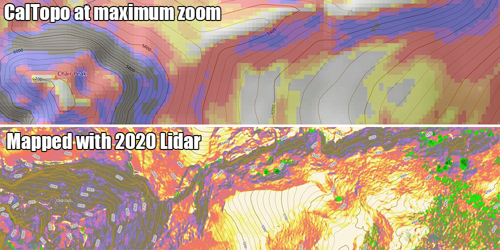
NOTE: CalTopo does use high resolution USGS lidar to compute relief and slope shading in some places, but coverage is also spotty. Also, they do not currently use this data for contour lines or for showing surface features.
As a reminder, no mapping source is perfect. They are only tools. Your safety is your responsibility. Happy hiking!
What is Lidar?
Source Data
| Map | Source Projects | |
|---|---|---|
|
Stevens Pass BETA |
||
|
Snoqualmie Pass BETA |
||
Map Legend
My map shows a combination of slope data and surface vegetation data.
Slope Shading Scale
 0°-10° (too flat to ski, or a possible campsite!)
27°-29°
30°-31°
32°-34°
35°-45°
46°-50°
51°-59°
60°+
Vegetation Scale
5 ft - 30 ft
30 ft - 100 ft
How I Made It
Here's a video tutorial showing the process I used to create this map. Maybe you can think of a better way to visualize the data?
Contact Me
Server Costs
This site is hosted on Cloudflare R2. It is fairly cheap to run: about $1.20 per month covering the domain name and storage costs for 40 GiB of map tile data.
If you found this map useful and would like to help keep the lights on, I would graciously accept a donation through PayPal.
Attributions
Mapping Data
Open Source
License
The lidar data used here is publicly available but it may be subject to additional usage restrictions. Consult WA DNR for details.
For the data that I own:
  MIT License

  Copyright (c) 2023 Jeff Heidel

  Permission is hereby granted, free of charge, to any person obtaining a copy
  of this software and associated documentation files (the "Software"), to deal
  in the Software without restriction, including without limitation the rights
  to use, copy, modify, merge, publish, distribute, sublicense, and/or sell
  copies of the Software, and to permit persons to whom the Software is
  furnished to do so, subject to the following conditions:

  The above copyright notice and this permission notice shall be included in all
  copies or substantial portions of the Software.

  THE SOFTWARE IS PROVIDED "AS IS", WITHOUT WARRANTY OF ANY KIND, EXPRESS OR
  IMPLIED, INCLUDING BUT NOT LIMITED TO THE WARRANTIES OF MERCHANTABILITY,
  FITNESS FOR A PARTICULAR PURPOSE AND NONINFRINGEMENT. IN NO EVENT SHALL THE
  AUTHORS OR COPYRIGHT HOLDERS BE LIABLE FOR ANY CLAIM, DAMAGES OR OTHER
  LIABILITY, WHETHER IN AN ACTION OF CONTRACT, TORT OR OTHERWISE, ARISING FROM,
  OUT OF OR IN CONNECTION WITH THE SOFTWARE OR THE USE OR OTHER DEALINGS IN THE
  SOFTWARE.